Seismic Activity in Kansas

The largest documented earthquake in Kansas struck in 1867 near Wamego and Manhattan and was estimated to have had a magnitude (M) of 5.0 to 5.5. Because that quake occurred before the advent of seismometers, its size could only be estimated based on damage and eyewitness accounts, which noted ringing church bells, tumbling chimneys, and cracked foundations among other incidents. The Nemaha Uplift—a 300-million-year-old buried mountain range that crosses Kansas diagonally—and adjacent Humboldt Fault Zone to the east coincide with the epicenter of the 1867 earthquake and other historic seismic events.
The largest Kansas earthquake in recent years was a M 4.9 event in 2014 that was thought to have been caused by induced seismicity. The epicenter was in Sumner County near Milan, where some buildings suffered minor damage.
At least 31 felt earthquakes in Kansas were documented in newspaper accounts and other sources between 1867 and 1976. A few of the later ones were also recorded with seismic equipment. Between 1977 and 1989, the KGS monitored a temporary network of seismometers throughout the state to study earthquakes and identify seismic risk. The equipment recorded more than 200 earthquakes during that time, ranging from M 0.8 to M 4.
The Kansas Earthquakes page on the KGS website includes a continuously updated interactive map that shows where earthquakes have occurred in the state since 2015. Data for each event are provided. Spreadsheets listing historic Kansas felt reports and historic Kansas recorded earthquakes also can be accessed there.

Historical Earthquakes in Kansas, Before 1977
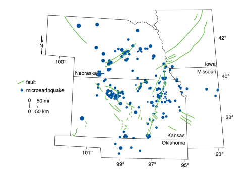
Microearthquakes
Microearthquakes recorded by the KGS, August 1977 to August 1989, size-coded by local magnitude.
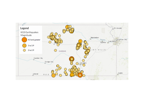
Earthquakes in Kansas in 2019