Geologic Maps
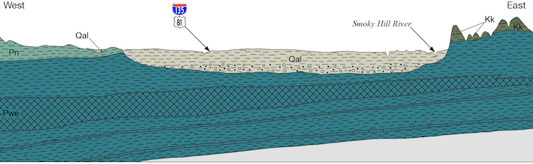
Geologic maps depict bedrock—the solid rock at the earth's surface or directly beneath the vegetation, soil, and thin deposits of unconsolidated material collectively called "cover." Limestone, sandstone, and shale are common types of bedrock in Kansas.
Soils and thin, unconsolidated surface or near-surface materials derived from bedrock through erosion are considered part of the cover and are generally not shown on geologic maps. However, in areas where bedrock is covered with thick and widespread deposits of sand, gravel, clay, silt, and other materials carried in by wind, water, and ice, the deposited material instead of the deeper bedrock is depicted on the map. Sediment deposits up to tens of feet thick in Kansas include alluvium, loess, sand dunes, and glacial drift.

Each geologic map graphically portrays the type, age, and distribution of surface or near-surface rock units in a state, county, region, or area of interest. Each unit is identified and named based on distinctive characteristics that can be mapped over large distances. For example, the Wreford Limestone, named after the unincorporated community of Wreford in Geary County, is found throughout the Flint Hills.
Lines, symbols, and colors on a geologic map show the relationship between rock units and accentuate the three-dimensionality of the bedrock. Folds, faults, fractures, and other geologic features created by deformation and displacement of the rocks are shown where they would appear if the overlying soil were stripped away. Lakes, rivers, roads, towns, and other natural and cultural features are included to help users pinpoint locations.
KGS geologic maps give a general description of the local geology and water and mineral resources.

Geologic maps and the digital data associated with them are helpful, and often essential, for any project that will affect or be affected by the type and structure of underlying bedrock, water resources, and other natural resources. Engineers, architects, developers, and city planners, in particular, use geologic maps to assess the feasibility of construction and development at a specific site. When the location of a floodplain or landslide hazard is not considered during urban development, a preventable disaster could occur. If building construction is not adapted to the local geology, concrete may crack, foundations may shift, basements may flood, and large structures may even collapse. Dam failures due to unstable geology endanger downstream communities and farms. Assessing the site’s geology before construction or other development increases the chance of foreseeing and avoiding construction failures, environmental damage, and natural disasters.
Geologic maps for Kansas counties are available from the Kansas Geological Survey. The KGS also has available a wall-size geologic map of the entire state and a map of the Tallgrass Prairie National Preserve in Chase County.