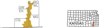
Chautauqua Hills

The Chautauqua Hills region—averaging just 10 miles in width—is a sliver of sandstone-capped rolling hills that splits the Osage Cuestas region from the southern Kansas border up to Yates Center in Woodson County. Small patches of similar terrain can be found as far north as Leavenworth County.
During the Pennsylvanian Subperiod, about 299 million to 323 million years ago, rivers and streams flowed into the sea in this area. Sand and other sediments collected in the estuaries and at the mouths of the rivers in deltas. Over time, the sediments were buried and compacted—the sands became sandstone and the muds became shale. Over millions of years, uplift and erosion exposed the sandstone and shale at Earth's surface. Further erosion has dissected the area into a series of low hills, capped by more resistant sandstone.
Sandstones capping the Chautauqua Hills are from the Tonganoxie Sandstone Member of the Stranger Formation and Ireland Sandstone Member of the Lawrence Formation. Ridges and troughs called ripple marks can be seen in some of the sandstone layers. These fossil ripple marks, created millions of years ago, provide information about the natural environment and direction of the current at the time they formed.

Because rock outcrops are prevalent, the hills are generally not cultivated for crops but used instead for pasture. The Verdigris, Fall, and Elk rivers cross the area in narrow valleys walled by sandstone bluffs. Topographic relief in the region varies up to about 250 feet.
The Chautauqua Hills physiographic region coincides with the Cross Timbers ecosystem, a patchwork of ancient hardwood forests interspersed with prairie grasses. That these geologic and ecological regions overlap is no coincidence because black jack oaks, post oaks, and other hardwoods of the Cross Timbers thrive in the sandstone environment. In Kansas, the extent of the Cross Timbers is almost identical to the extent of the Chautauqua Hills physiographic region. Although the name "Chautauqua Hills" is used only in Kansas, the Cross Timbers region stretches through Oklahoma and down into north-central Texas.
The area encompassing the Cross Timbers State Park and adjacent Toronto Lake in Woodson County is one of the best public places in the region to view sandstone outcrops and hardwood forests. Tree-ring dating of core samples collected from 26 mature post oak trees in the park in 1982 revealed five of the trees sampled had inner rings dating back to 1724, 1727, 1736, 1737, and 1740.