Skip to main content
The University
of
Kansas
MENU
link to menu page
THE UNIVERSITY
of
KANSAS
Kansas Geological Survey
GeoKansas
myKU
Email
Canvas
Enroll & Pay
Jayhawk GPS
Close
Search this unit
Start search
Submit Search
Main navigation
Home
Earthquakes, Sinkholes, Landslides, and Environmental Issues
Select to follow link
Earthquakes
Select to follow link
Monitoring Earthquakes in Kansas
Seismic Activity in Kansas
Induced Seismicity
Measuring Earthquake Magnitude and Intensity
Sinkholes
Select to follow link
Wallace County Sinkholes
Cargill and Other Reno County Sinkholes
Crawford Sinkhole, Russell County
Big Basin and Little Basin, Clark County
Landslides
Environmental Issues
Select to follow link
Carbon Dioxide Sequestration
Cleanup from Mining in Kansas
Hutchinson Natural Gas Explosion
Radon
Explore the State
Select to follow link
Explore Northwest Kansas
Select to follow link
Arikaree Breaks
Castle Rock
Cedar Bluff State Park
Lake Scott State Park
Monument Rocks
Mount Sunflower
Little Jerusalem Badlands State Park and Smoky Valley Ranch
Explore Southwest Kansas
Select to follow link
Big Basin and Little Basin
Clark State Fishing Lake
Meade State Park
Point of Rocks
Explore North-Central Kansas
Select to follow link
Coronado Heights
Kanopolis State Park
Mushroom Rock State Park
Pawnee Indian Museum State Historic Site
Post Rock Country
Rock City
Explore South-Central Kansas
Select to follow link
Cheyenne Bottoms
Fort Larned National Historic Site
Quivira National Wildlife Refuge
Red Hills Scenic Drives
Sand Hills State Park
Explore the Flint Hills
Select to follow link
Chase County Courthouse and Cottonwood Falls
Konza Prairie Biological Station
Pillsbury Crossing Wildlife Area
Scenic Drives in the Flint Hills
Tallgrass Prairie National Preserve
U.S. 56 Roadcut East of Council Grove
Explore Northeast Kansas
Select to follow link
Alcove Spring
Clinton Spillway
Echo Cliff
Glacial Hills Scenic Byway
Kaw Point Park
Kaw River State Park
Mount Mitchell Heritage Prairie
Overland Park Arboretum & Botanical Gardens
Quartzite Boulders
Riverfront Park, Atchison
Explore Southeast Kansas
Select to follow link
Butcher Falls
Cross Timbers State Park and Toronto Lake
Elk Falls
Mined Land Wildlife Area
Schermerhorn Park and Cave
Spring River Wildlife Area
U.S. Highway 160 from Longton to Elk City
Physiographic Regions
Select to follow link
Arkansas River Lowlands
Select to follow link
Rocks and Minerals of the Arkansas River Lowlands
Chautauqua Hills
Select to follow link
Rocks and Minerals of the Chautauqua Hills
Cherokee Lowlands
Select to follow link
Rocks and Minerals of the Cherokee Lowlands
Flint Hills
Select to follow link
Rocks and Minerals of the Flint Hills
Glaciated Region
Select to follow link
Rocks and Minerals of the Glaciated Region
High Plains
Select to follow link
Rocks and Minerals of the High Plains
Osage Cuestas
Select to follow link
Rocks and Minerals of the Osage Cuestas
Ozark Plateau
Select to follow link
Rocks and Minerals of the Ozark Plateau
Red Hills
Select to follow link
Rocks and Minerals of the Red Hills
Smoky Hills
Select to follow link
Rocks and Minerals of the Smoky Hills
Wellington-McPherson Lowlands
Select to follow link
Rocks and Minerals of the Wellington-McPherson Lowlands
Geologic Exploration: Tools and Techniques
Select to follow link
Basic Geology, Paleontology, and Fieldwork
Seismology
Drilling
Maps and Mapping
Select to follow link
Geologic Maps
Topographic Maps
Color Elevation Map of Kansas
Public Land Survey System
Kansas High Plains Aquifer Atlas
Interactive Kansas Oil and Gas Well and Field Map
Geologic Time
Select to follow link
Geologic Time: A Metaphor
Geologic Periods in Kansas
Select to follow link
Cenozoic Era
Mesozoic Era
Paleozoic Era
Precambrian, Proterozoic Eon, Archeon Eon, and Hadean
Understanding How Geologists Talk About Time
Mass Extinctions
Select to follow link
Mass Extinction at the End of the Cretaceous Period
Mass Extinction at the End of the Permian Period
Rocks, Minerals, and Fossils
Select to follow link
Rocks in Kansas
Select to follow link
Caliche
Chalk
Chert
Coal
Dolomite
Gypsum
Kimberlite
Limestone
Meteorite
Oolite
Quartzite
Rock Salt
Sand, Gravel, and Other Sediment
Sandstone
Shale
Minerals in Kansas
Select to follow link
Agate
Barite
Calcite
Dolomite (Mineral)
Galena
Gypsum (Mineral)
Halite (Salt)
Lead
Marcasite
Opal
Sphalerite
Zinc
Fossils in Kansas
Select to follow link
Vertebrate Fossils in Kansas
Select to follow link
Bison
Claosaurus
Giant Camel (Gigantocamelus)
Hesperornis Regalis
Mammoth
Mastodon
Mosasaur
Niobrarasaurus
Plesiosaur
Pterosaur
Saber-Toothed Cat (Smilodon)
Shark
Silvisaurus
Short-Legged Rhinoceras (Teleoceras)
Invertebrate Fossils in Kansas
Select to follow link
Ammonoids
Brachiopods
Bryozoans
Clams and Their Relatives
Corals
Crinoids
Fusulinids
Insects
Snails and Other Gastropods
Sponges
Trilobites
Geologic Curiosities
Select to follow link
Concretion
Cone-in-Cone
Geodes
Mud Cracks and Rain Prints
Ripple Marks
Geoarchaeology
Stratigraphic Nomenclature
Water, Oil, and Natural Resources
Select to follow link
Water in Kansas
Select to follow link
Surface Water and Groundwater: What's the Difference
Select to follow link
Aquifers
Kansas Lakes and Rivers
Watersheds and River Basins
Riparian Zones
Phreatophytes: Plants That Suck Up Groundwater
Wetlands
Playas
Springs
Water Quality, Quantity, and Regulations
The Hydrologic (Water) Cycle
Mining and Quarrying
Select to follow link
Coal Mining
Gypsum Mining
Lead and Zinc Mining
Salt Mining
Sand, Gravel, and Crushed Stone Operations
Oil and Natural Gas in Kansas
Select to follow link
Oil and Gas Production in Kansas
Coalbed Methane
Oil and Gas Records
Drill Cores and Cuttings
Info for
Prospective Students
Current Students
Alumni
Degree Programs
THE UNIVERSITY
of
KANSAS
University of Kansas logo
Kansas Geological Survey
GeoKansas
Menu
link to menu page
Search this unit
Start search
Submit Search
Home
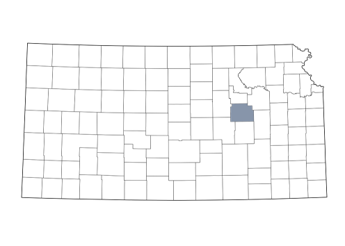
U.S. 56 Roadcut East of Council Grove Gallery
Morris County Roadcut
Morris County